
 | Page 385 |  |
Wartime experience with flying and photography made Crawford a pioneer archaeological air-photographer (though he was not the very first as air photographs of Stonehenge had been taken from a balloon in 1905). He worked at first by searching out the archaeological features on military photographs, which had, of course, been taken with other purposes in mind. In 1922, he lectured with aerial photographs of Hampshire that showed the archaic “Celtic” field systems of late prehistory. That success led to the publications Air Survey and Archaeology (1924); Wessex from the Air by Crawford and Alexander Keiller (1928), which reported the results of special flying over Wessex to take new photographs from a hired airplane; and the textbook Air Photography for Archaeologists (1929). In these publications, the distinctive earthwork traces from English prehistory were better defined, and the characteristics of later distractions, e.g., pillow mounds built as artificial rabbit warrens, were identified.

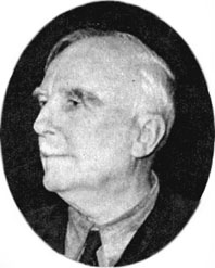
O. G. S. Crawford
(Ann Ronan Picture Library)
Those founding texts of air photography report observations made just in time to record the earthworks of the southern England chalk land before plowing ripped them up. There is an astonishingly crisp detail on a great many of the early classic photographs. Building on the access the survey had as a state agency to military and other government aerial photographs, Crawford made it the focus for the new discipline. After retiring from the survey, he took up fieldwork again in northeastern Africa. In 1927, Crawford founded the journal Antiquity, which he edited until his death.
Much of the archaeological record of the Ordnance Survey was lost in the bombing of its Southampton office in 1940. Reorganizations many years later transferred the survey’s archaeological interests into those of the royal commissions for ancient monuments in England, Scotland, Wales, and Northern Ireland, where they are combined also with the aerial-photographic archive as part of the present consolidated field and survey records of each nation’s archaeology.
In Man and His Past, begun during World War I and published in 1921, Crawford set out the enduring fundamentals of his view of archaeology, which I think might best be described, in its developed form, in terms of its being a “topographical landscape history.” He valued the enormous mass of information in, for example, the many large-scale manuscript maps that had been made of country estates over the decades, and he photographed these maps at the survey to bring the scattered reports into a centralized archive record. The weakness of the previous topographic work lay in its woolly and unhistorical approach. The idea of classifying human settlements by their function and position in a structured landscape was sound, but one needed a clear framework of chronology and some decent knowledge of function to put it into some reasoned order. There is now a distinctive style of British landscape archaeology that combines detailed study and mapping of surface earthworks with aerial photography and limited excavation at those points where key relationships may be shown stratigraphically; this robust and practical approach owes much to Crawford’s influence and example, which was perfectly straightforward and very well thought through. (Crawford once said to English archaeologist sir mortimer wheeler about Antiquity,
 |  |