

| Page 247 | |
archaeology has witnessed a slow but promising resurgence that began with conservation activities in the Angkor region. Such work has been difficult because fighting between government troops and the Khmer Rouge continued in parts of northern Cambodia for most of the 1990s. Cambodia’s legacy of land mines, poor infrastructure, and inadequate transportation routes have also slowed archaeological work of all kinds. Yet the Angkorian past—and Cambodia’s cultural heritage—remains an important symbol of nationalism and Khmer ethnic identity. In fact, national pride is a major catalyst behind efforts to resume archaeological work throughout the country and train students in archaeological and conservation techniques.
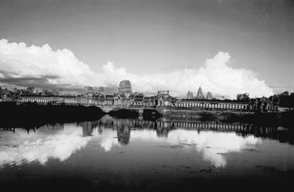
Part of the moat at the vast Angkor Wat temple complex
(Hulton Getty)
Much of the archaeological research in Cambodia since 1995 has taken place in collaboration with the Ministry of Culture and Fine Arts, which is responsible for training students in the archaeology department at the Royal University of Fine Arts (RUFA). One example involves the study of the circular earthwork sites of Kompong Cham by international teams of German, Japanese, and U.S. archaeologists working with RUFA students and faculty members. Their research documents variability in the earthwork sites in order to draw comparisons with sites on the Vietnamese side of the border and develop a chronology of the settlements that were first built around 4000 b.p. Collaborative work at Angkor Borei (in Takeo Province) since 1995 has involved the University of Hawaii’s East-West Center and the Royal University of Fine Arts. Research by the Lower Mekong Archaeological Project has established the settlement of this large site in the middle of the first millennium b.c. and has begun to chronicle the region’s settlement history before the rise of settlements in Vietnam such as Oc Eo.
New archaeological research directions have also been evident in and around Angkor since the mid-1990s, most obviously in the many applications of remote-sensing data to archaeological questions. The use of remote-sensing data was appealing for several reasons: it offered an alternative to field survey in an area made unsafe, until recently, by land mines, and it also had broad geographic scope. Archaeologists have used remote-sensing data to identify dozens of pre-Angkorian
| |