

| Page 1096 | |
ranging from 0.3 to 0.4 μm. On the other end, following the red band, are three different categories of infrared (IR) waves: near-IR (.07–1.3 μm), mid-IR (1.3–3 μm), and thermal-IR (less than 3 μm).
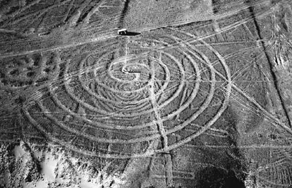
The still-enigmatic Nazca geoglyphs in Peru were not discovered until the 1920s, when planes began to fly over the desert; the glyphs, often over 100 meters in diameter, are visible only from the air.
(Marilyn Bridges/Corbis)
Length of wave is of prime importance in remote sensing because it will determine the type of interaction that electromagnetic energy will have with the objects sensed from the earth’s surface. For example, the blue band is able to penetrate water bodies; thus it is particularly useful in coastal mapping. The red band is useful for sensing chlorophyll absorption and, hence, in differentiating vegetation cover from nonvegetation, including cultural features, while the near-IR has proved useful for determining vegetation types.
On the other side of the spectrum, we have the microwave radiation of electromagnetic energy, which consists of radio waves that range from 1 millimeter to 1 meter in length, and it cannot be recorded by standard optical means but it can be recorded by special radar. Radar is the acronym for radio detection and ranging, and as its name suggests, it uses radio waves to detect the presence of objects and determine their position. Radar imagery, then, is rather different from aerial photography or satellite imagery. The latter are passive sensors that depend on the sun as the source of electromagnetic energy and can therefore use only the visible and infrared wavelengths of the spectrum to create images. Radar is an active sensor that emits its own electromagnetic energy in the form of radio waves to create images.
Remote sensing in the form of aerial photographs has been used in archaeology since at least the early 1900s. J. Capper is credited with having taken the first photographs of an archaeological site, Stonehenge, from a hot air balloon in 1906. These photographs, however, were more a novelty than a conscious archaeological venture. The first conscious use of aerial photography for archaeological purposes was in 1913 when Sir Henry Wellcome took photographs of his excavations in the Sudan using a
| |